
The Daehanjiji (Korean Geography) locates Korean territory as from lat. 33 degrees N 15 minutes to 42 degrees 25 minutes and from long. 124 degrees E 30 minutes to 130 degrees 35.
Takeshima/dokdo Dokdo is located at about 131°52′ East longitude and about 37°14′ North latitude.[3] The western islet is located at 37°14′31.
That means takeshina/dokdo is the outside Korean territory.
Korean geography has a map attached to it.
Let's look at it.


The first one is 1899 Korean geography. Can you see Usando干山?
Well it is difficult to say which island 干山 pointing at. But one thing is clear; There is no Dokdo drawn on it.
The second map is 1907 Korean new geography. Can you see Usando干山? No you cannot. It disappeared from the map.
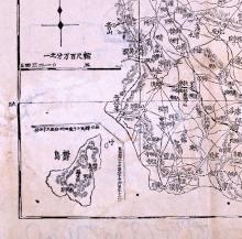
The third map is also 1907 map that is about Gyeongsang Province which Ulleungo belongs to. You can see Ulleungdo the lower left surrounded in a line,
Can you see Usando干山? No, instead you see the letter 竹, bamboo.in the northeast of Ulleungo.
It is probably Chukdo(竹島)(see the modern map)

Now the texts says;Usando is southeast of Ullleungdo
And Korea claim Usando is Dokdo, and since Dokdo is southeast of Ullleungdo, they claim the text make it clear that Korea knew Dokdo.
But there is no reason why the text has to mention the islet which does not belong to Korean territory according to the text itself. Besides, keep in mind that there is no Dokdo on the maps attached to them.
It is rather reasonable to assume the author just mistook "northeast" for "southeast."
Then everything makes sense. 干山=Usando=竹=竹島=Chukdo=the north east of Ulleungdo
The maps are from ☆大韓ニダの介の韓国研究~韓国企業で働いた経験を持つ著者の嫌韓批判&反日批判
No comments:
Post a Comment